Who maintains what?
Find out who is responsible for maintaining local infrastructure: Property owners, Council or other service providers.
We maintain
Infrastructure Council maintains and manages are listed below.
Footpaths
You can report an area where concrete, asphalt or brick paved footpath panels:
- are raised
- are broken or damaged from tree roots
- are showing natural wear and tear causing surface to break up
- have damaged pit surrounds or lids
- have any other footpath maintenance issues.
To report a footpath that is damaged or raised, please fill out the report a raised or damaged footpath form.
Local roads
We maintain all roads within the municipality apart from the main arterial roads below. If you see a pothole, please use our report a pot form.
A Register of Public Roads is a list of public roads and associated infrastructure which are managed and maintained by a Victorian road authority. All road authorities must make this list publicly available in accordance with the Road Management Act 2004.
Council owned stormwater
Bayside maintains
- 415 kilometres of drainage pipes
- 15,500+ drainage pits
Bayside proactively and reactively inspects, investigates, and maintains drainage issues affecting properties, Council roads and parks while also assessing areas of the drainage network for potential upgrades.
We carry out an annual program of high-pressure jetting, root cutting and cleaning of drainage pipelines.
We don't maintain
The infrastructural items below are maintained by a variety of government organisations or the property owner.
Vehicle crossings
The cost of construction and maintenance of vehicle crossings is the full responsibility of the property owner. The responsibility extends from the boundary line of the property to the edge of the road pavement, excluding the footpath section of the vehicle crossing.
The two sections of the channel adjacent to the road are Council’s to maintain, but the responsibility of the property owner during a new build or full replacement of the crossing.
If an existing vehicle crossing is damaged or impacted by either Council works, the maintenance of Council assets or tree root incursion from a Council tree, Council will undertake the necessary investigations and respond accordingly.
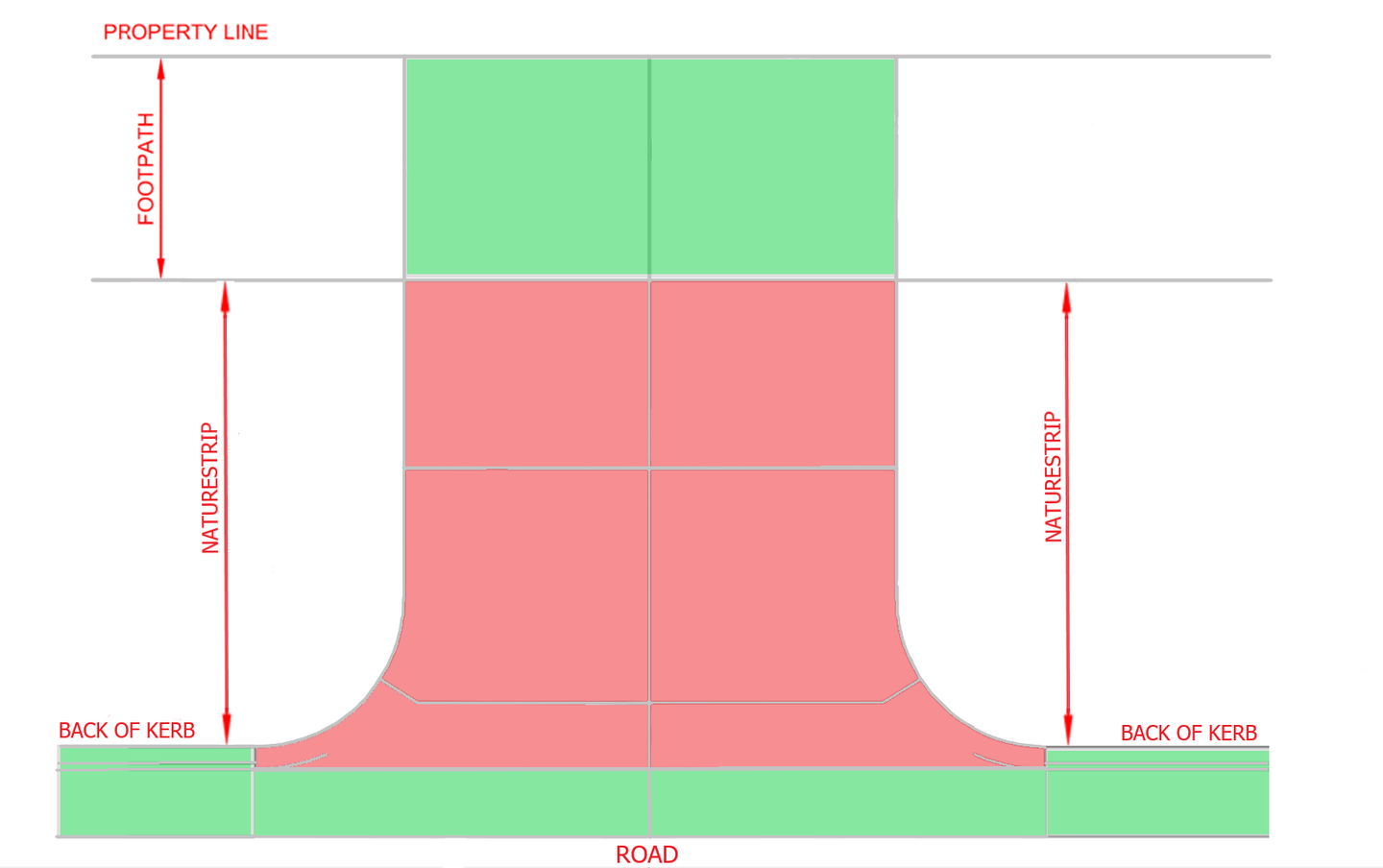
pink = property owner, green = council
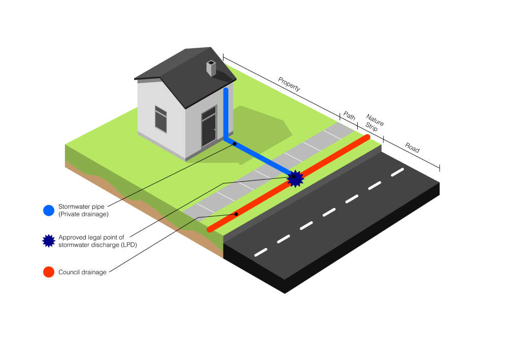
House storm water pipes and Legal Point of Discharge pipes
Are the responsibility of the property owner from within the property to the Council drainage pipes/pits or Kerb and Channel. The Legal Point of Discharge (LPD) pipes are either in the easement of the property or under the footpath and nature strip. Properly constructed and maintained pipes are designed to withstand normal tree roots and traffic loadings. Poor or failed joints makes it possible for fine roots to enter a cracked pipe and expand inside the pipe as root growth occurs. Cleaning the roots out of the pipe is only a temporary solution. The problem can be permanently resolved if the damaged pipes are replaced or repaired.
The image below illustrates the position of stormwater pipes on a property and their connection to Council's drainage. Stormwater pipes are a property owners' responsibility up until it's connection to the approved legal point of stormwater discharge (LPD).
Where excavation is required to be undertaken within the road reserve (footpath and nature strip), a Bayside City Council Road Opening Permit must be obtained.
Sewer pipes
Sewer transports wastewater away from your property to a main sewer that is maintained by South East Water.
Water supply
Water supply mains are maintained by South East Water.
Main arterial roads
Department of Transport, DoT (formerly VicRoads) manages all maintenance on the main arterial roads in Bayside. This includes:
- road signs
- kerb and channel
- drains
- road opening permits on the arterial road surface
- dead animals
- all trees on the central median (except on South Road).
The roads managed by VicRoads in Bayside are:
- Balcombe Road, Black Rock to Beaumaris
- Bay Road, Sandringham to Cheltenham
- Beach Road, Brighton to Beaumaris
- Bluff Road, Hampton to Black Rock
- Centre Road, Brighton East
- Cummins Road, Brighton East
- Glen Huntly Road, Brighton
- Hampton Street, Brighton East to Hampton
- Hawthorn Road, Brighton East
- Nepean Highway, Brighton to Hampton East
- North Road, Brighton to Brighton East
- St Kilda Street, Brighton
- South Road, Brighton to Brighton East
- The Esplanade, Brighton
To report a road issue, please contact DoT via enquiries@roads.vic.gov.au or visit VicRoads.
Nature strips
Nature strips in front of private properties are the responsibility of the property owner or occupier.
We run a tree planting program where you can request a nature strip tree.
Street lighting
The maintenance of street lighting is managed by United Energy. If there is a street light fault, please contact Powercor.
Water from a neighbouring property
Any water entering your property from a neighbouring property which has been identified as a non-Council issue is deemed a civil matter and is to be resolved between the respective owners.
Council has no legislative powers to intervene.
Access to easements
An easement is an area of land, or part of an allotment, reserved by law to allow provision of common state or municipal controlled infrastructure for a specific purpose, such as: stormwater drainage.
Property owners with registered easements on their title under the Water Act 1989, are legally required at all times to provide Council with full and free access to enter, to inspect, maintain or upgrade drainage works on the land.
Our easement page has further information if required.